Triglav National Park
Slovenia's only national park: Triglav, valley towns, and a sparse overview for planning, not a path dump.
Maps
Park overview first. Corridor sheets add planning detail where they exist.
Park overview (Map 1)
Full map / print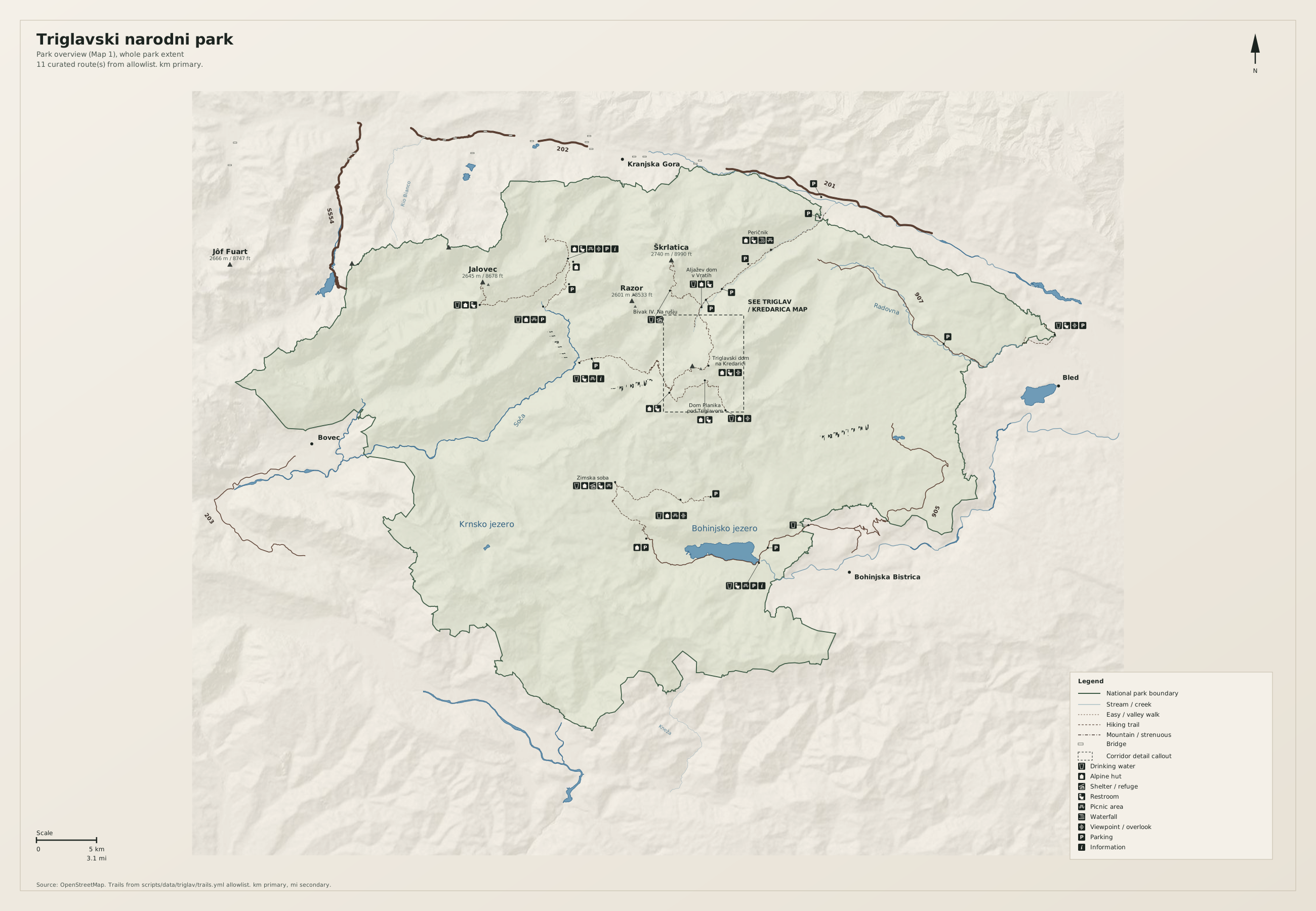
Triglav / Kredarica corridor (Map 2)
Full map / print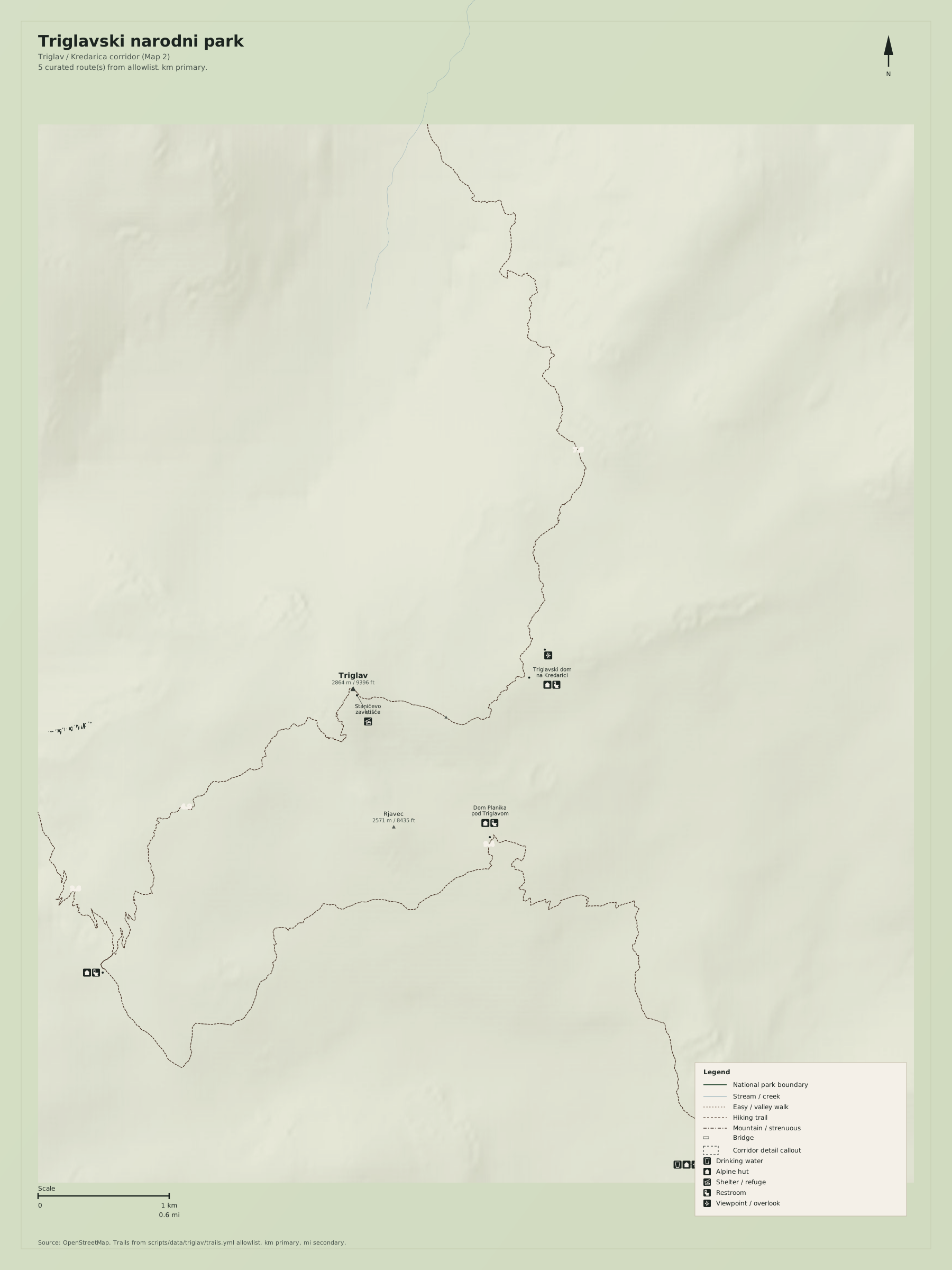
Overview
Triglavski narodni park is compact next to Hohe Tauern and still too big for a path dump. Map 1 is an orientation sheet: boundary, a few massifs, gateway towns, and a handful of trail spines. The dashed frame marks the Triglav / Kredarica approaches.
Use Slovene toponyms as on the ground (Triglav, Kredarica, Bohinjsko jezero). Distances on the map are kilometres first, miles second.
Natural highlights
What is worth seeing on foot. Elevations in meters (and feet on the map).
Triglav · 2864 m
Highest summit in Slovenia and the park namesake. Approaches are serious alpine terrain via Kredarica or Planika. The visitor overview is the massif, not a casual walk to the top.
Bohinjsko jezero
Large lake on the south-east park edge. A gateway, not a wilderness pond. Treat it as orientation water on Map 1.
Soča / Trenta
West-side valley into the heart of the Julian Alps. Vršič is the high road, not a trail substitute.
Trailheads & parking
Where to leave the car (or bus) to get close to what you want to see.
Aljažev dom / Vrata
Valley parking in Vrata toward Triglav north face. Seasonal; fills on fair days.
Bohinj / Ukanc
Lakeside and valley lots at the west end of Bohinj. Walk into Komna; do not treat the lake shore as the park.
Trenta / Vršič
Roadside lots on the Vršič pass road. The pass is a driving saddle; hiking starts from signed trailheads.
Trails
Distances are useful order-of-magnitude figures for planning, not survey-grade GPS tracks.
Triglav via Kredarica (allowlist review)
Along the way: Triglav
Map 1 spine only. Not a day-stroll. Conditions and via ferrata gear vary by route.
Bohinj to Komna
Along the way: Bohinjsko jezero
Order-of-magnitude distance. The lakeshore is busy; Komna is the park.
Getting there
Pick a valley (Bohinj, Vrata, Trenta, Kranjska Gora) and stay on that side. The Vršič road is seasonal and not a transit spine across the park.
By car
A2 to Jesenice then local roads to Kranjska Gora or Bled/Bohinj; Bovec / Trenta from the Soča side.
By transit
Trains to Jesenice or Bled, then buses to Bohinj, Kranjska Gora, or Bovec. Confirm seasonal Vršič buses.
Parking
Valley lots fill on fair summer days. Vršič roadside parking is not a campground.
Intentionally left off
European tourism sites push these hard. This map does not, so the nature signal stays readable.
- Bled castle and island tourism (Bled is a gateway town, not the park)
- Zip-lines, canyon-ticket parks, and rafting product maps
- Every alpine hut in the Julian Alps (Map 1 names hub huts only)