Hohe Tauern National Park
Austria's largest national park: three states, high glaciers, and a sparse overview sheet for planning, not a path dump.
Maps
Park overview first. Corridor sheets add planning detail where they exist.
Park overview (Map 1)
Full map / print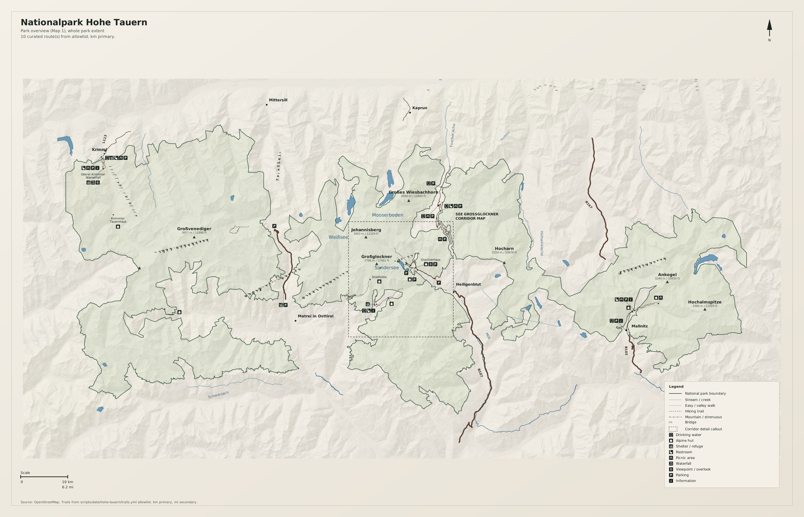
Großglockner / Pasterze corridor (Map 2)
Full map / print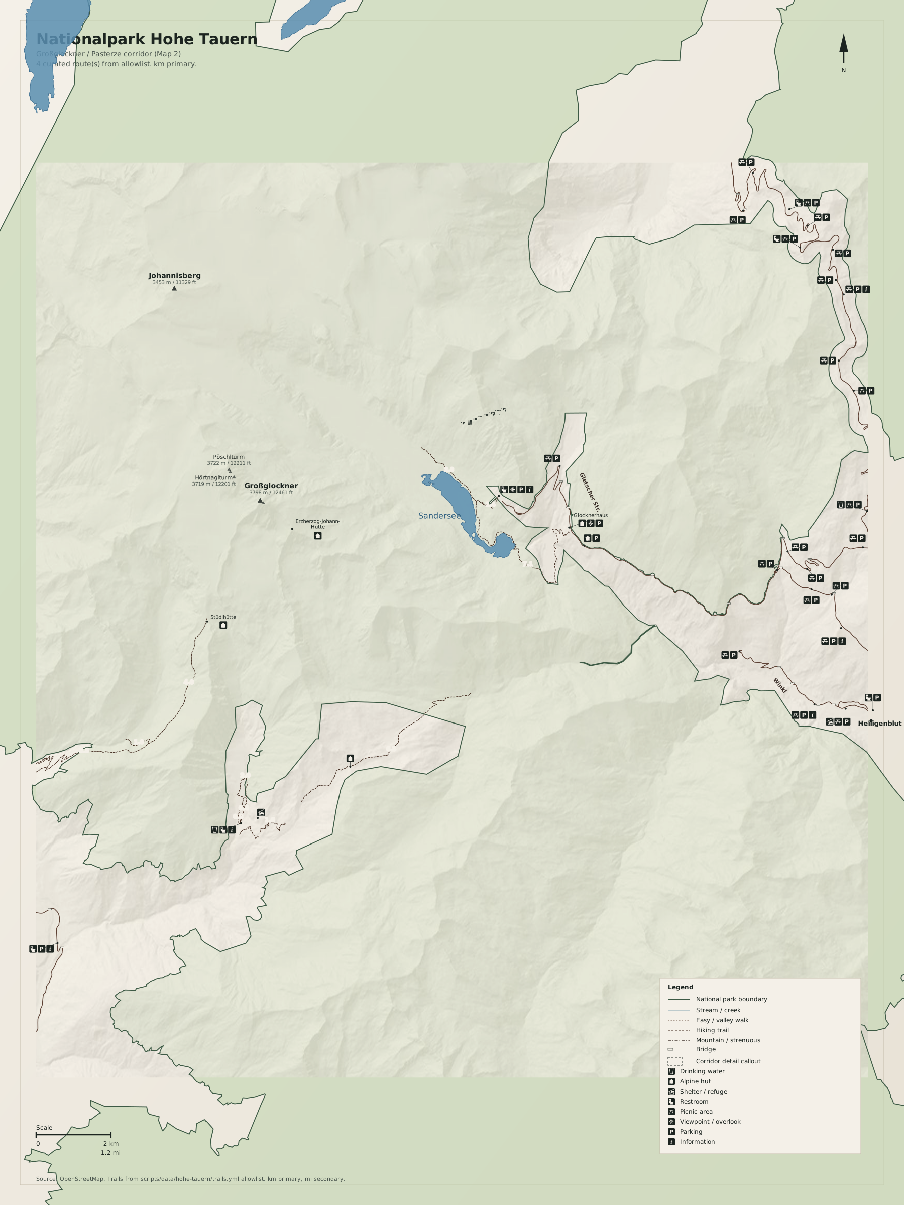
Overview
Nationalpark Hohe Tauern is much larger than Berchtesgaden. Map 1 is an orientation sheet: park boundary, a few massifs, major peaks, gateway towns, and a handful of trail spines. The dashed frame marks the Großglockner / Pasterze corridor; Map 2 zooms that window with segment distances and denser visitor POIs.
Use German toponyms as on the ground (Großglockner, Pasterze, Krimml). Distances on the map are kilometres first, miles second.
Natural highlights
What is worth seeing on foot. Elevations in meters (and feet on the map).
Großglockner · 3798 m
Highest summit in Austria, in the Glocknergruppe. Approaches are serious alpine terrain. The visitor overview is the High Alpine Road viewpoint, not a casual walk to the top.
Pasterze
Austria’s longest glacier, below the Glockner east face. Seen from Kaiser-Franz-Josefs-Höhe. The ice is receding; treat the viewpoint as the planning destination on Map 1.
Großvenediger · 3666 m
Dominant peak of the Venedigergruppe in the west of the park. Glacier approaches; not a valley stroll.
Krimml Waterfalls
Stepped falls on the Krimmler Ache at the northwest park edge. A signed valley walk from Krimml village; crowded in season.
Kaiser-Franz-Josefs-Höhe
Road-end overlook of the Pasterze and Großglockner. The Map 1 dashed frame is this corridor.
Trailheads & parking
Where to leave the car (or bus) to get close to what you want to see.
Heiligenblut / Großglockner High Alpine Road
Paid lots along the B107, including Kaiser-Franz-Josefs-Höhe. The road is toll and seasonal. Arrive early on fair days.
Krimml
Village lots below the waterfall entrance. Walk the signed path; do not treat the waterfall ticket site as the park.
Matrei in Osttirol
Town parking; valley approaches into the Venediger and Granatspitz groups. Confirm current lots on site.
Mallnitz
Village parking on the Carinthia side (Ankogel / Malta approaches).
Mittersill / Kaprun
North-side gateways. Kaprun has reservoir access (Mooserboden) that is more logistics than a hiking spine on Map 1.
Trails
Distances are useful order-of-magnitude figures for planning, not survey-grade GPS tracks.
Pasterze viewpoint (road access)
Along the way: Pasterze, Großglockner
The Map 1 corridor callout. Short walks at the viewpoint; glacier trails change with ice retreat. Not a summit route.
Krimmler Ache valley
Along the way: Krimml Waterfalls
Order-of-magnitude distance into the Achental. The waterfall section is busy; the upper valley is the park.
Glockner approaches (allowlist review)
Along the way: Großglockner
OSM hiking relations on Map 1 are a sparse [review] seed, not a complete AV network. Treat as orientation spines.
Getting there
The park is a long east-west band. Pick a gateway (Mittersill, Matrei, Heiligenblut, Mallnitz, Krimml) and stay on that side of the range. Do not plan to drive across the crest except on the seasonal High Alpine Road.
By car
A10 / B108 Felbertauern for the north and Matrei; B107 Großglockner High Alpine Road (toll, seasonal) for Heiligenblut and the Pasterze viewpoint; B106 / Mallnitz for the Carinthia side.
By transit
ÖBB to Zell am See, Spittal/Millstätter See, or Lienz, then regional buses toward Mittersill, Krimml, Matrei, Heiligenblut, or Mallnitz. The High Alpine Road is not a transit spine.
Parking
Viewpoint lots on the Glockner road fill on fair summer days. Krimml waterfall parking is a separate village system. Overnight rules vary; read posted signs.
Intentionally left off
European tourism sites push these hard. This map does not, so the nature signal stays readable.
- Grossglockner High Alpine Road as a driving attraction (it is access, not the park)
- Reservoir dams and Kaprun power-station tourism
- Glacier ski areas and summer snow-park marketing
- Alm dining experiences and souvenir clusters
- Every alpine hut in the range (Map 1 names hub huts only)