Berchtesgaden National Park
A steep Alpine national park where trails, peaks, and cold water matter more than ticketed rides.
Maps
Park overview first. Corridor sheets add planning detail where they exist.
Park overview (Map 1)
Full map / print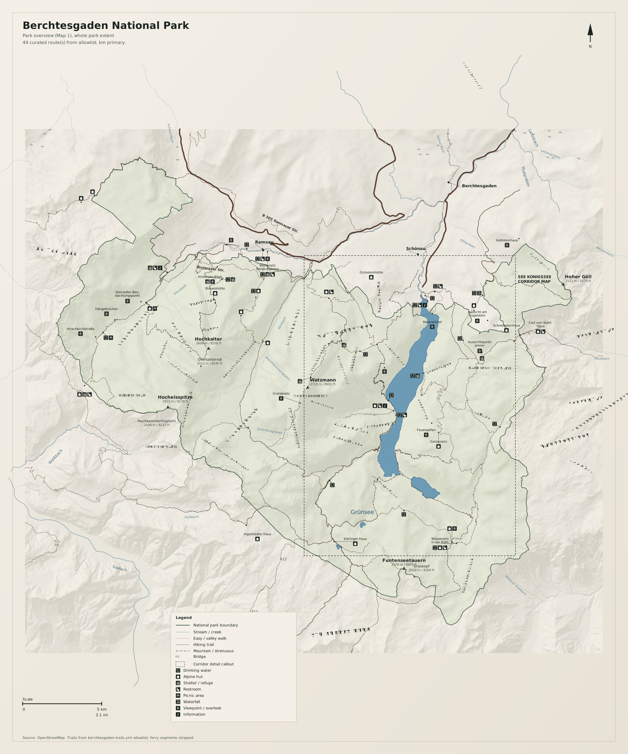
Königssee corridor (Map 2)
Full map / print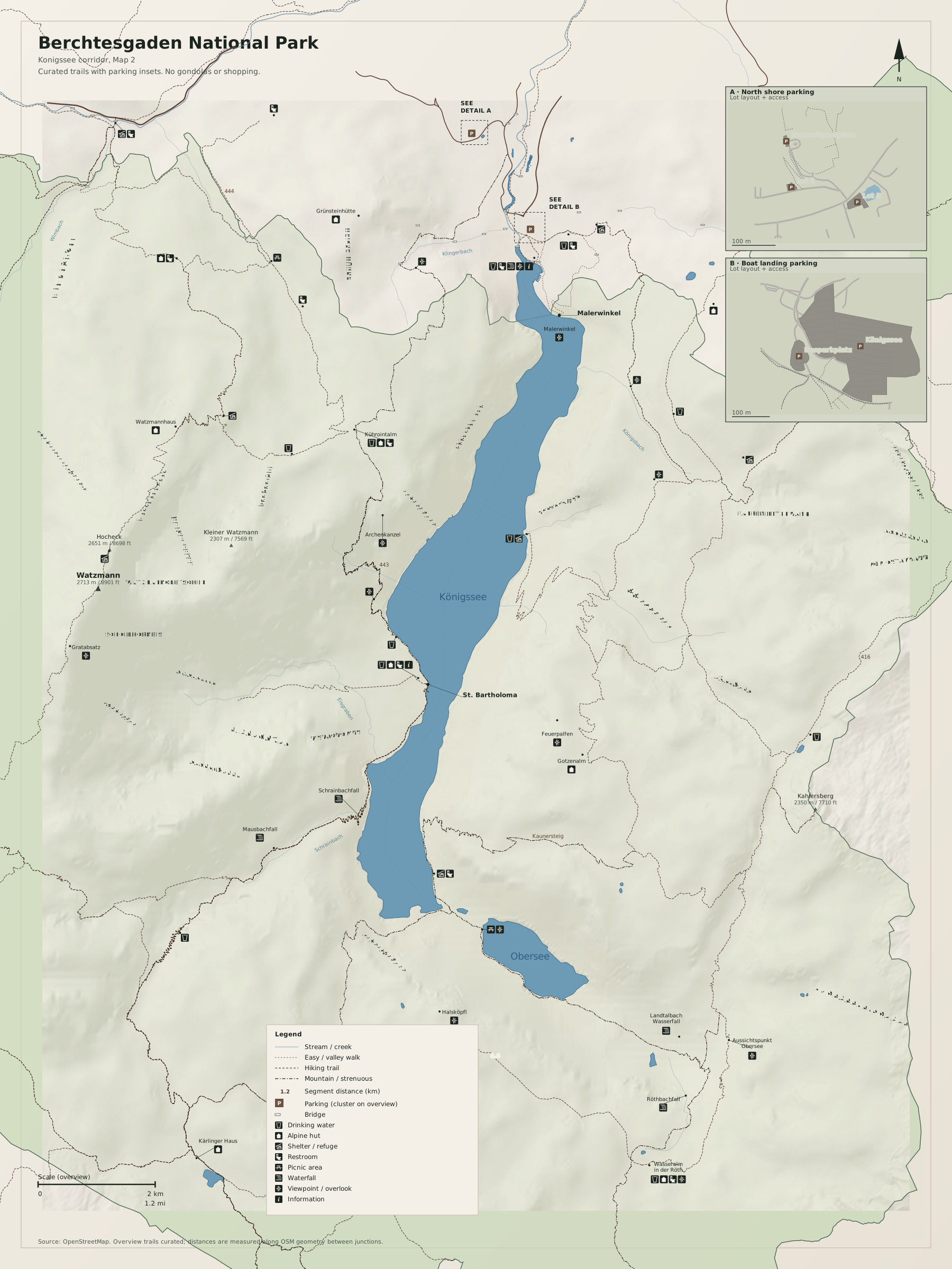
Trail pick list (review): OSM hiking relation catalog
Overview
Berchtesgaden National Park is steep limestone, cold water, and long sightlines. This page covers the Königssee corridor: where to park at the north shore, which short walks open the classic views, and which longer routes leave from mid-lake trailheads.
Use the map as you would a US National Park Service valley sheet. Read peaks, water, parking, and named trails first. Paid rides and town attractions are left off on purpose.
Natural highlights
What is worth seeing on foot. Elevations in meters (and feet on the map).
Königssee
Long, fjord-like lake running north–south through the park core. Clear water and sheer walls; the north shore is the main public access.
Obersee
Smaller high lake beyond the south end of Königssee. Reached on foot from the St. Bartholomä area after lake access.
Malerwinkel
Classic north-shore view down the lake toward the Watzmann massif. Short, signed walk from the Schönau parking area.
Watzmann · 2713 m
Dominant west-side massif above the lake. Approaches are serious mountain hiking; treat as alpine terrain, not a casual stroll.
Jenner · 1874 m
East-side summit above Schönau. Hiking routes exist from the valley; ignore cable-car marketing and plan as a foot ascent if that is your goal.
Eiskapelle
Ice field / snow remnant below the Watzmann east face, reached on foot from St. Bartholomä. Conditions change; expect rough trail and cold air.
Trailheads & parking
Where to leave the car (or bus) to get close to what you want to see.
Schönau Seelände / Königssee north shore
Large paid lots at Schönau am Königssee (seek P1–P4 style lots near the lake; arrive early in peak season).
Malerwinkel path start
Same Schönau north-shore lots; walk east along the shore signs for Malerwinkel.
St. Bartholomä (lake access)
No drive-up trailhead. Reach by electric boat from Schönau, then hike. Frame the boat as logistics to trail, not as a sightseeing cruise product.
Jenner / east-side valley approaches
Valley parking in Schönau / Jenner area; confirm current lot names on site. Start hiking from the valley floor rather than treating the upper station as the trailhead.
Trails
Distances are useful order-of-magnitude figures for planning, not survey-grade GPS tracks.
Malerwinkel walk
Along the way: Malerwinkel, Königssee
Out-and-back lakeshore walk. Best first stop if you want orientation without a long day. Crowded mid-day; early or late is quieter.
Königssee east-shore paths (north sector)
Along the way: Königssee
Use for shoreline walking near the north end. Distances vary by turnaround; the map marks the usable public shore corridor, not every social path.
Eiskapelle from St. Bartholomä
Along the way: Eiskapelle, Watzmann east face
Round-trip order of magnitude ~3–4 km depending on snow line. Boat schedule controls your day. Not a valley stroll—bring layers and footwear for wet rock.
Obersee from St. Bartholomä
Along the way: Obersee, Königssee south end
Combine only if boat timing and weather allow. Steeper and longer than Malerwinkel; treat as a half-day from the landing.
Jenner by trail (valley start)
Along the way: Jenner
Approximate round-trip distance if you hike both ways from the valley. Elevation gain is the story—plan time and weather. Cable car is omitted as an attraction; use only if you treat it as optional transport, not the point of the visit.
Getting there
Most visitors base from Schönau am Königssee at the north end of the lake. Park once, walk for viewpoints, and use the boat only when a trailhead sits mid-lake.
By car
Drive to Schönau am Königssee (south of Berchtesgaden town). Follow signs for Königssee parking. Do not expect free roadside parking at the shore in season.
By transit
Train to Berchtesgaden, then local bus toward Königssee / Schönau. Schedules change seasonally—check Deutsche Bahn / local bus boards the morning of your hike.
Parking
North-shore lots fill on fair-weather weekends. Have a backup plan (later start, Malerwinkel only, or a different trail day). Overnight parking rules vary by lot—read posted signs.
Intentionally left off
European tourism sites push these hard. This map does not, so the nature signal stays readable.
- Jennerbahn / gondolas marketed as the experience
- Toboggan runs, mountain carts, and adventure parks
- Alm dining “experiences” and souvenir shopping clusters
- Foto-point marketing markers and themed attraction stops
- Salt mine and other paid indoor attractions near town
- Eagle’s Nest / Kehlsteinhaus as a nature destination